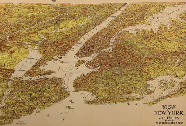
- George J. Nostrand
- View of New York and Vicinity showing Good Automobile Roads, 1927
- Color Map, Lithograph
- Framed: 27 x 34.5 in (68.58 x 87.63 cm)
This map was reissued over many years with updates. The map’s date was determined by the small plane on the horizon flown by Charles Lindbergh, who made his famous solo flight across the Atlantic Ocean in the late 1920s. The fact that it shows the George Washington Bridge (originally named the Hudson River Bridge) also helps with dating. The Bridge opening destroyed most of the ferry business from New Jersey, so the fact that no ferries are marked above the bridge helps us also determine the date (this is unlike earlier versions). Thank you to Dr. Glen Gabert for the generous donation of this map.
- Current Location: STEM (Science, Technology, Engineering, and Mathematics), 263 Academy Street - 2nd Floor Lobby
- Collections: American Political Culture, Natural Landscape and Urban Landscape, Prints and Editions, Works by Men
Other Work From Hudson County Community College