- Betsy Boynton
- Basic types of remote sensing technologies
- Vector Art
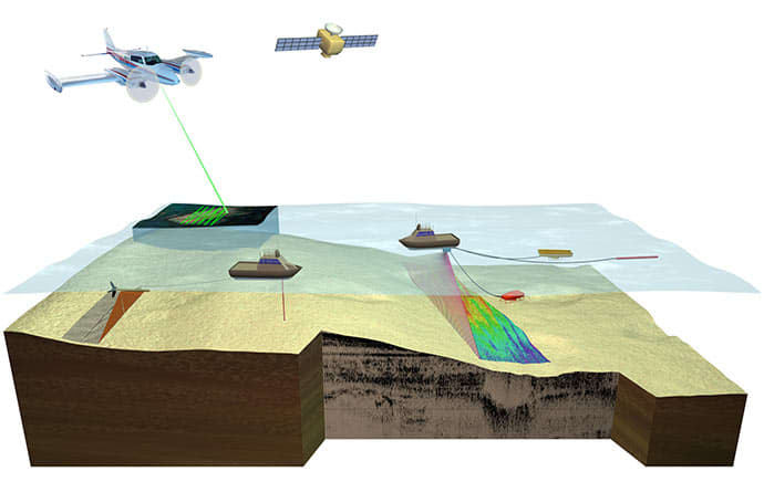
Figure 1. Diagram illustrating basic types of remote sensing technologies with application to benthic habitat mapping. (A) Side-scan sonar; (B) Lidar; (C) Color aerial or satellite imagery; (D) Single-beam sonar; (E) Multibeam or swath sonar; (F) Seismic acquisition; (G) Bottom visualization; (H) water column data collection.
Moses, C.S., Nayegandhi, A., Brock, J., and Beavers, R., 2010, USGS-NPS Servicewide Benthic Mapping Program (SBMP) workshop report: U.S. Geological Survey Open-File Report 2010–1194, 32 p.
About the Artist: Betsy Boynton x
Betsy Boynton has over 20 years of experience in illustration and graphic design as a full-time contractor to the U.S. Geological Survey, St. Petersburg Coastal and Marine Science Center. Her job as a Multimedia Specialist includes a wide variety of tasks, but scientific illustration is her favorite. She is passionate about creating engaging visuals that can assist in providing effective science communication to diverse audiences. She works regularly with scientists to convey complex research topics in order to make their science more accessible. Over the years, her illustrations have been featured and published in a wide variety of scientific journals and USGS publications. Her primary illustration tools are Adobe Illustrator and Photoshop. She is also proficient in Modo 3D software and occasionally takes on free-lance work. She strives to create illustrations that foster a greater understanding of our world.