Dorit Feldman Legacy Fund archive
.דורית פלדמן הייתה אמנית מושגית רב-תחומית . לאורך דרכה האמנותית היא קיימה דיאלוג רעיוני רצוף עם המרחב התרבותי של אמנים ויוצרים מתחומי הפילוסופיה, המדע והספרות
Message
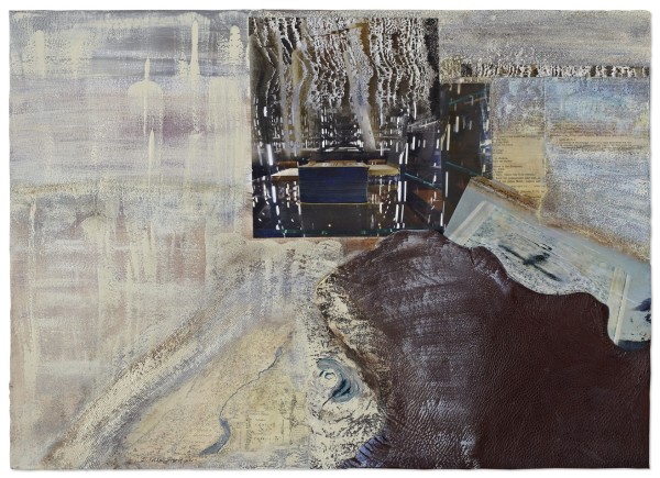
In Syrian-African Rift Valley, Tectonic Motion, the depth of the photographic paper is manifested in the geological depths via computer processing of rock folds, freezing their slow, yet significant movement as testimony to ancient times. The markings of the country's map on a Dutch etching dating to the early 18th century accentuate the contours of the lake region above the Syrian-African rift valley. The original map was scanned and digitally processed into and from sections which resemble ancient parchment scrolls or drawing residues (palimpsest) on brittle plates. Nonrealistic reflections of the earth plates as tectonic plates from the depths of the earth burst forth from the waters of the thick sea. From overview, the marked route of the geological rift emerges as a metaphor for the state of brittleness and rift in the Mediterranean. Another exegetic stratum refers to the accumulating data of geographic-anthropological research, learning that along the "corridor"—the Syrian-African Rift fault, the population of prehistoric Africa increased toward the European continent—toward progress. The contour of the fault appears in the photograph rather as that of a river whose sweet waters fed the growth of vegetation, allegorizing the notion of coveted reconstruction.
ב'קו השבר (הסורי אפריקאי), תנועות טקטוניות', 2013, 'עומקו של נייר הצילום' מתבטא בעומקים הגיאולוגים, באמצעות עבוד ממוחשב של קימוטי סלע בהקפאת תנועתם האיטית אך משמעותית, כעדות לתקופות זמן קדומות. סימוני מפת הארץ, בלוח תחריט הולנדי מתחילת המאה ה 18, מדגישים את תוואי אזור הימות שמעל לאזור השבר הסורי אפריקאי . המפה המקורית נסרקה ועובְּדה במחשב אל תוך ומתוך מִקטעים הנראים כמגילות קלף עתיקות או כשרידים רישומיים (פלִימְפסֶסְט) על גבי לוחות פְּריכִים. השתקפויות שלא מן המציאות, של לוחות אדמה כ'לוחות טקטוניים' ממעבה כדור הארץ, מבצבצות ממימיו של הים הסמיך. ממבט- על נראה סימון התוואי של אותו שבר גיאולוגי כמטפורה למצב ה'שבר' הפריך של אגן המזרח התיכון. כאשר רובד פענוח נוסף לסימבוליקת העבודה, מתייחס למידע המצטבר במחקר הגיאוגרפי- אנתרופולוגי, כי לאורכו של 'המסדרון'- הקו השבר הסורי אפריקאי , עלתה אוכלוסיית אפריקה הקדומה הפרהיסטורית , אל עבר יבשת אירופה – אל עֵבר הקִדמה. תוואי ה'שבר', מופיע בתצלום דווקא כתוואי של נהר, שמימיו המתוקים אפשרו צמיחה ירוקה, הצמיחה כמָשל למושג הרקונסטרוקציה הנִכְסֵפת.
- Current Location: Studio
Other Work From Dorit Feldman Legacy Fund archive