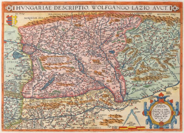
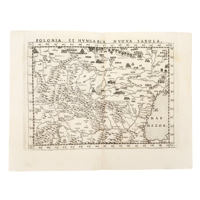
• Portfolio
  • Collections
  • Artists
  • Log In
Artwork Archive Logo
  • Discovery
M Art Museum

M Art Museum

Message
  • Portfolio
  • Collections
  • Artists
Poland and Hungary by Girolamo Ruscelli
  • Girolamo Ruscelli
  • Poland and Hungary, 1574
  • Copper engraving on laid paper
  • 23 x 31 cm
  • Available
  • Inquire
  • Share
  • Facebook logo facebook Share this blog post via Facebook
  • Twitter logo twitter Share this blog post via Twitter
  • LinkedIn logo linkedin Share blog post via LinkedIn
  • Email logo email Share this blog post via email
Prev
Next

The map of Poland and Hungary was printed by the Italian geographer, humanist and publisher Girolamo Ruscelli (1500-1566) as part of his atlas La Geografia. The copy is part of an edition published in 1574 in Venice and takes over an earlier work first published by Sebastian Munster in 1544. The map includes Transylvania and Banat and the Black Sea appears under the old name of Mar Mazor.

  • Collections: Maps, Old Maps, Romanian Maps

Other Work From M Art Museum

Wallachia, Serbia, Bulgaria, Romania, Amsterdam (2nd pcs) by Gerardus Mercator
Transylvania and Hungary, by Abraham Ortelius, Orbis Terrarum edition, Antwerp by Abraham Ortelius
Transylvania, Basel by Sebastian Münster
Romaniae, by Iacobo Castaldo, printed by Abraham Ortelius, Orbis Terrarum edition, Antwerp by Abraham Ortelius, Iacobo Castaldo
Description of Hungary, Orbis Terrarum edition, Antwerp by Abraham Ortelius
Roman Empire, Orbis Terrarum edition, Antwerp by Abraham Ortelius
Ancient World, Inspired by Ptolemy's Geography, Parergorn edition, Antwerp, (2nd pcs) by Abraham Ortelius
Transylvania, by Johannes Sambucus (Janos Zsamboky), printed by Abraham Ortelius, Orbis Terrarum edition, Antwerp by Abraham Ortelius, Johannes Sambucus
Dacia, after "The geography of Ptolemy", Basel by Sebastian Münster
Youth by George Mazilu
See all artwork from M Art Museum
 

Powered by Artwork Archive