- Betsy Boynton
- Shifting Baselines map/brochure: inside
- Vector Art
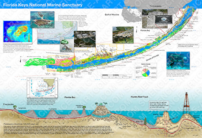
Inside view of "Shifting Baselines in the Florida Keys National Marine Sanctuary," a general information product in map-fold brochure format for the Keys Marine Lab. By Eugene Shinn (USF), Barbara Lidz (USGS), John Ogden (FIO), and Brian Keller (NOAA). Florida Keys benthic map by B. Lidz. Design, layout, and graphics (unless noted) by Betsy Boynton.
About the Artist: Betsy Boynton x
Betsy Boynton has over 20 years of experience in illustration and graphic design as a full-time contractor to the U.S. Geological Survey, St. Petersburg Coastal and Marine Science Center. Her job as a Multimedia Specialist includes a wide variety of tasks, but scientific illustration is her favorite. She is passionate about creating engaging visuals that can assist in providing effective science communication to diverse audiences. She works regularly with scientists to convey complex research topics in order to make their science more accessible. Over the years, her illustrations have been featured and published in a wide variety of scientific journals and USGS publications. Her primary illustration tools are Adobe Illustrator and Photoshop. She is also proficient in Modo 3D software and occasionally takes on free-lance work. She strives to create illustrations that foster a greater understanding of our world.