Guild of Natural Science Illustrators
The GNSI is a 501(c)(3) that connects, provides professional development & networking opportunities to visual science communicators
Message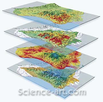
- Theophilus Britt Griswold
- GIS Mapping Initiative in Colombia
- Color
This set of 3D relief maps was created for The Nature Conservancy Magazine as an example of the power of database systems and science data to focus the work of conservationists. Using scientist supplied data from GIS mapping systems, the art was created in desktop 3D software; then edited and color corrected for 4 color process seperations in Photoshop. The study area is the Sierra Nevada region along the northern coast of Colombia, South America. It shows, from the bottom up: Biological Diversity, Development Patterns, Threatened Areas, and Critical Lands to be saved as soon as possible..
- Collections: Geology, Maps & Signs